Established 2002
Contact details

Follow us on:

Written and designed by Roy Shepherd. Special
thanks to my wonderful wife
Lucinda Shepherd, friend Robert Randell and various experts for their support.
How Great Britain Formed
Lucinda Shepherd, friend Robert Randell and various experts for their support.
How Great Britain Formed
Britain’s geological history and rock record is remarkably complex. When considered in a broader context the rocks are actually telling the story of how Britain has moved around the Earth’s surface and the various environments and events it has encountered on the way. It can be described as a chronological list of geological periods and their respective rock types: Carboniferous coals, Triassic sandstones, Jurassic limestones and clays, Cretaceous chalks, etc. The record is difficult to interpret because many processes are acting at once: plate tectonics, continental drift, sea-level change and climate change.
Important concepts
Orogeny: when continental plates collide the area of impact experiences uplift, typically producing mountain-chains of deformed rock with associated volcanics. The impact is referred to as an orogeny.
Rifting: continental plates can be pulled apart, in a process known as rifting, and new oceanic crust is generated between them. Prior to rifting the crust thins as it is stretched, normally bringing the land surface below sea-level. When rifting occurs molten material rises up, causing the crust to swell, typically creating a mountainous ridge along the line of the rift (a mid-ocean-ridge).
Supercontinents: the continental plates repeatedly assemble to form a supercontinent which then rifts apart, until the dispersed continents eventually reassemble again in a different arrangement.

The two major divisions of the last eon are the Palaeozoic and the Mesozoic, which are characterized by the assembly of the supercontinent Pangea, and by its break-up respectively. Britain has always been located on continental margins and, as such, has been subject to collisions and rifting since the Precambrian.
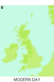
It's sensible to pick up the story of Britain in the Cambrian as Britain’s Precambrian history is complicated and poorly known.


ADVERTISEMENT BY UKGE - OFFICIAL ADVERTISING PARTNER OF DISCOVERING FOSSILS
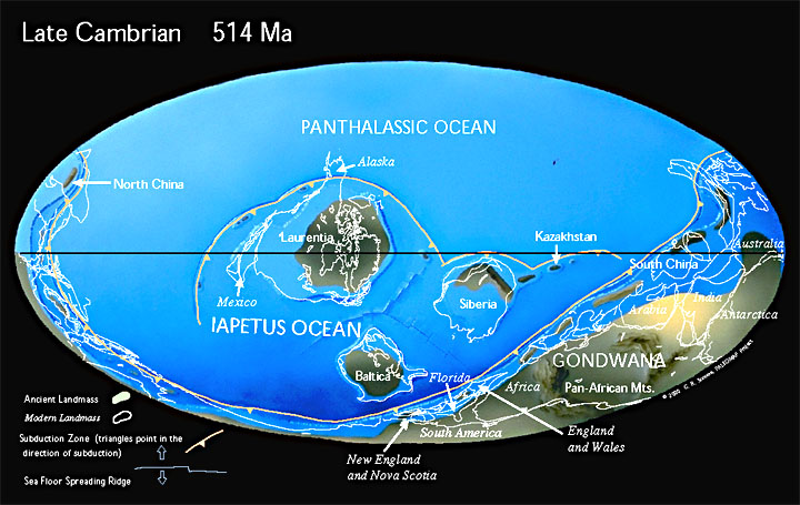
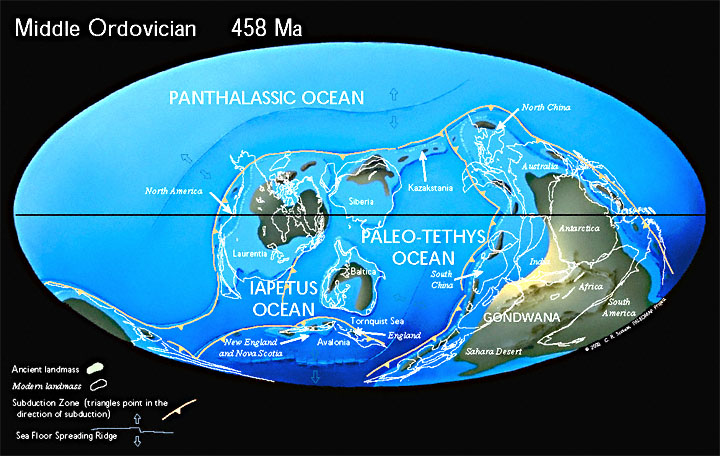
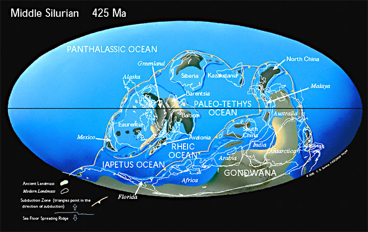
Cambrian - Ordovician – Silurian (550 - 400 million years ago)
Both England, Wales and Scotland are in the southern hemisphere but are separated by the Iapetus Ocean. Scotland is attached to a plate comprised mainly of North America and Greenland. England and Wales are part of an arc-shaped microcontinent, perhaps comparable to modern Indonesia, along with Scandinavia and Newfoundland. England and Wales, and Scotland are both situated on continental margins and under marine waters for most of this period.
The Iapetus Ocean is slowly closing and by the Silurian the two continental blocks collide producing the Caledonian orogeny. The Scottish Highlands and the Scandinavian Mountains are remnants of this mountain chain. The collision brings England & Wales and Scotland together.
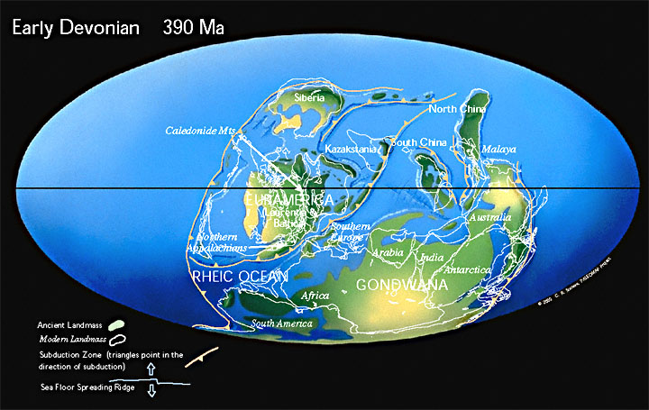
Devonian (400 - 350 mya)
The uplift of the Caledonian orogeny brings most of Britain above sea-level and terrestrial sediments are shed off of the Caledonian mountains. Britain is situated in the southern desert-belt and the resulting sediments are arid sandstones (the Old Red Sandstone).
The Caledonian Orogeny is largely over, but Britain is now effected by a new orogeny to the south: the closure of the Rheic Ocean which lies between Southern Europe and Northeast Africa. The closure of the Rheic is one of the final stages of Pangea’s assembly, as Africa and South America crash into North America and Europe.
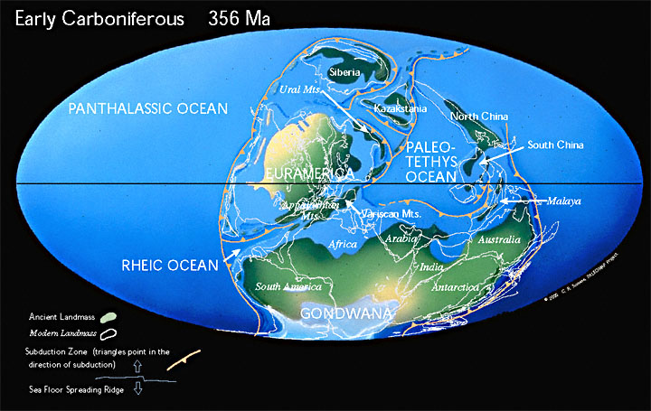
Carboniferous (350 - 280 mya)
Britain has now migrated into the equatorial forest-belt and coal swamps abound. Sea-levels rise. The assembly of Pangea is finally complete and Northeast Africa presses into Southern Europe producing the Hercynian Orogeny. SW Britain lies within the Hercynian mountain chain. Dartmoor, Bodmin Moor, and the other igneous bodies of the SW are remnants of this collision event.

ADVERTISEMENT BY UKGE - OFFICIAL ADVERTISING PARTNER OF DISCOVERING
FOSSILS
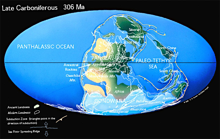
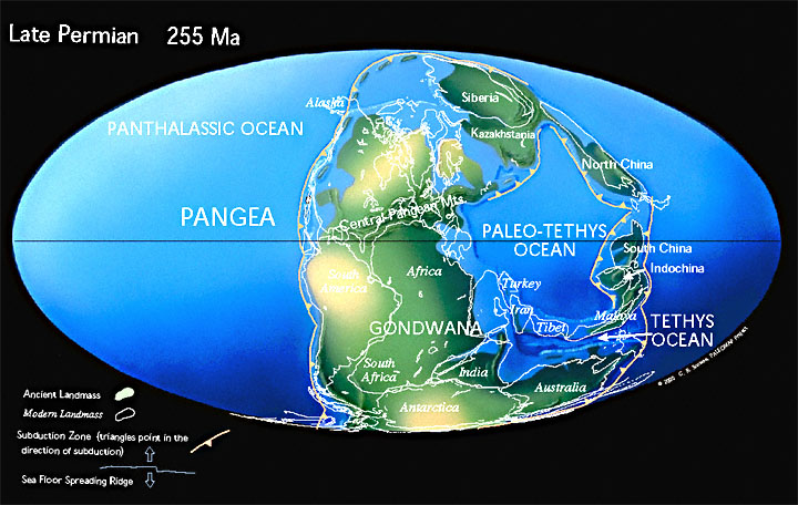
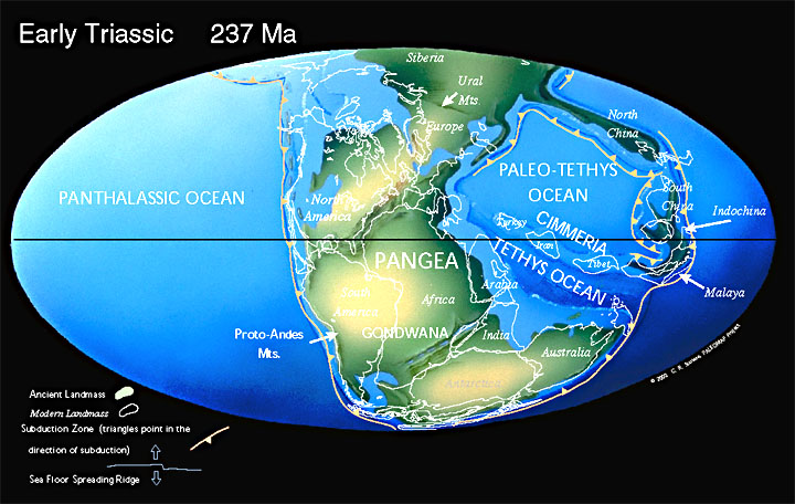
Permian - Triassic (280 - 190 mya)
Britain enters the northern desert-belt. The assembly of Pangea and the Hercynian Orogeny are accompanied by a worldwide drop in sea-level. Britain is now in a very similar situation to the Devonian: above sea-level, with mountains shedding sediment into a desert environment (producing the New Red Sandstone).
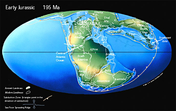
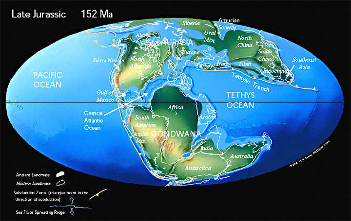
Jurassic (190 - 140 mya)
Pangea begins to break-up and global sea-levels begin to rise. Rifting begins in preparation for the opening of the Atlantic Ocean. Britain is situated within the immediate zone of rifting and begins to subside, allowing marine waters to flood in from the Tethys (to the Southeast) and later from the boreal too (to the North). Sea-levels fell again at the end of the Jurassic.
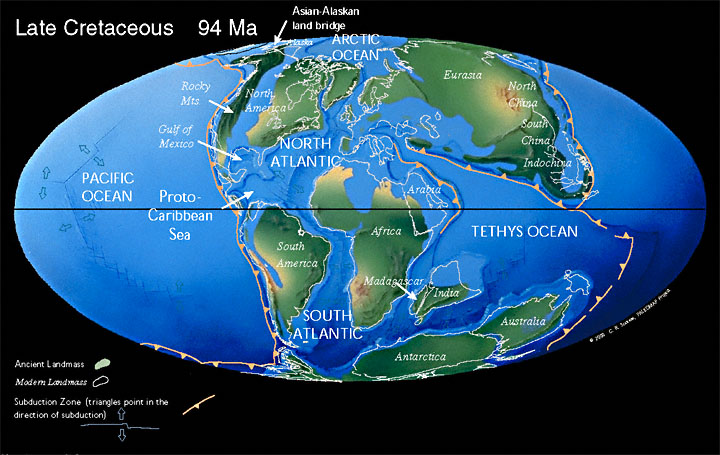
Cretaceous (140 - 65 mya)
Global sea-levels rise again, and by the Late Cretaceous they have reached what is possibly their all-time high. This probably relates to the break-up of Pangea; intense and widespread rifting activity causes the mid-ocean-ridges to swell, which in turn displaces much of the ocean’s waters onto the continents. With much of the land flooded there is little source for terrestrial sediments, instead plankton deposit extensive chalks over much of the continental shelves. The North Atlantic begins to open just west of Britain.
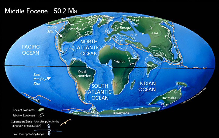
Palaeogene (65 - 22 mya)
Atlantic opening spreads north between Britain and Greenland, leading to volcanics along the west coast of Scotland and in Northern Ireland. The islands of Aran, Mull and Skye are remnants of these volcanoes, and the Antrim Basalts (including the Giant’s Causeway) are remnants of the lava which flooded out. Africa, Arabia and India are moving north towards Europe and Asia, closing the Tethys Ocean.
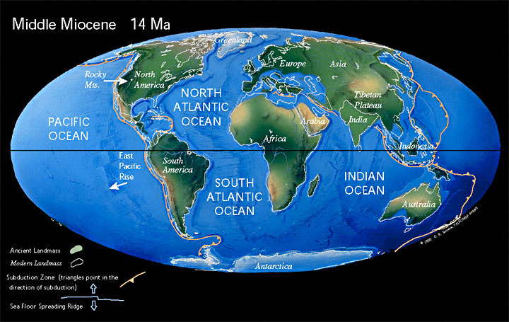
Neogene (22 - 2 mya)
Tethys closes and glaciation begins. India and Arabia crash into Asia, producing the Himalayan and Zagroa Mountains respectively. Africa hits Europe creating the Alps, the effects of which reach Britain creating the gentle but large scale folding seen in the south (Isle of Wight, South Downs, North Downs, Weald). The Mediterranean is a remnant of the Tethys which will eventually close, and the volcanics in the region (Vesuvius, Etna, Stromboli, etc.) are products of this closure.
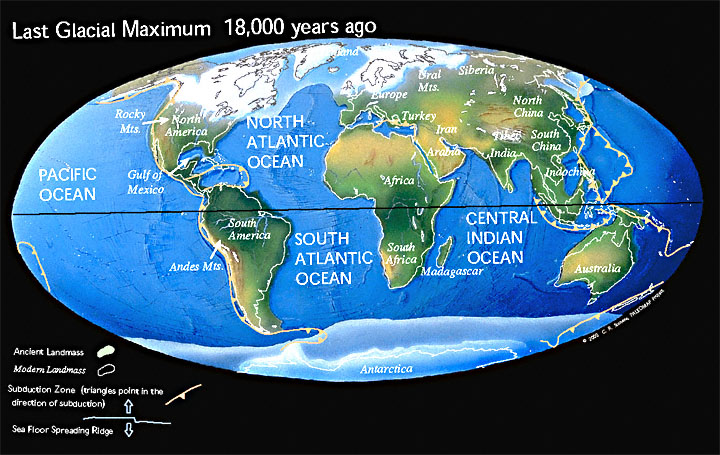
Quaternary (2 - 0 mya)
Arctic ice-sheets periodically migrate south and then retreat as global sea-levels simultaneously fall and rise.
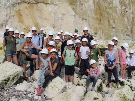
Join us on a fossil hunt
Left: A birthday party with
a twist - fossil hunting at
Peacehaven.
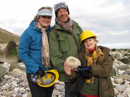
Right: A family hold their prized ammonite at Beachy Head.
Discovering Fossils guided fossil hunts reveal evidence of life that existed millions of years ago. Whether it's your first time fossil hunting or you're looking to expand your subject knowledge, our fossil hunts provide an enjoyable and educational experience for all. To find out more CLICK HERE